Disaster response help from satellite data
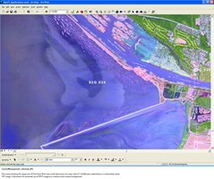
Coastal municipalities will be able to identify future impacts of climate change and sea level rise using new maps launched today by the Dept of Climate Change and Energy Efficiency (DCCEE).
Developed in partnership with the CRCSI the maps use the highest resolution elevation data currently available. The new tool highlights low-lying areas in Melbourne, Sydney, Hunter and Cental Coast NSW, Perth and South East Queensland. Minister for Climate Change and Energy Efficiency, Greg Combet, said coastal areas were a “priority for adaptation action”.
“The maps provide useful initial information to decision-makers to prepare for potential risks from rising sea levels in coastal areas,” Mr Combet said.
The inundation maps identify coastal areas that are vulnerable to one of three sea level rise scenarios for the period leading up to the year 2100. The scenarios are low sea-level rise (0.5m), which is likely to be unavoidable; medium sea-level rise (0.8m); and high sea-level rise (1.1m), which is the high-end risk identified in the fourth assessment report of the Intergovernmental Panel on Climate Change.
Mr Combet said governments would need to prepare for the impacts of climate change on new and existing developments. “Early engagement with communities in these areas will be critical to the development of workable adaptation solutions for local areas, so they are able to avoid risk,” he said. “Where this is not possible, this engagement will help ensure they are as prepared as possible to cope with climate change impacts as they arise.”