News
New ties made with Europe
CANBERRA, Wednesday 7 March 2018: The European Association of Remote Sensing Companies (EARSC) and the Cooperative Research Centre for Spatial Information (CRCSI) through Spatial Information Systems Research Ltd (SISR), signed a Memorandum of Understanding (MoU). Representatives from the EARSC member companies AIRBUS, e-geos, Earth-i, Geospatial Enabling Technologies, GMV, Planet, and Sinergise attended the ceremony.
NZ tech firm tests ground-breaking satellite technology
Satellites orbiting more than 20,000km above the earth’s surface are now trying to locate and record what lies beneath in a new trans-Tasman initiative spearheaded by Christchurch geospatial technology company Orbica.
World first for Australian maritime industry
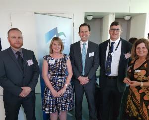
L-R: Marcus Eckholm (MIAL), Julia Mitchell (CRCSI), Senator Matt Canavan, Dr John Dawson (Geoscience Australia), Alison Saunders (MIAL).
Industry trial of Australian Satellite-Based Augmentation System officially launched
The Australian Government today launched a trial of Satellite-Based Augmentation System (SBAS) for the Australasian region at an event at CQUniversity Australia’s Rockhampton campus.
Panel discussion explores CRCSI collaboration with India
Exploring collaboration opportunities in geospatial technology and policy, a panel discussion was held during a visit to New Delhi on 11 April 2017. After meeting with Shri Y. S. Chowdary Hon'ble Minister of State for Ministry of Science & Technology and Ministry of Earth Sciences, the panellists, Dr. Peter Woodgate (CEO, CRCSI) Dr. Zaffar Sadiq Mohamed Ghouse (CRCSI Director-International Relations), Mr. Gregory Harvey, Trade Commissioner, Australian Trade, and Investment Commission and Dr. Swarna Subba Rao, Surveyor General of India, Survey of India discussed the India-Australia collaborative model. Geospatial Media and Communication hosted the panel discussion.
© 2024 CRCSI | Disclaimer | Privacy Policy